Since 2016, the City has been working with the local neighbourhood to mitigate traffic impacts in the Cloverley community when there are incidents or stalls on the Second Narrows Bridge or Highway 1.
With the upcoming new elementary school in the Cloverley neighbourhood, the City’s focus is helping students walk and roll as independently and safely as possible—that includes exploring options for intersection improvements, installing missing sidewalks along priority school routes, improving sightlines, and other physical improvements identified by future students, families, and neighbours.
At this time, the City is not considering the installation of more physical measures like barriers or street closures, due to the impact these will have on local access for residents, visitors, and emergency and street operation vehicles.
You may find more information on the Cloverley School webpage.
2021 Onwards
In response to community feedback and data collected over the last year, the traffic calming measures identified on the map below were removed in early Summer 2021 due to ineffectiveness and low levels of neighbourhood support.
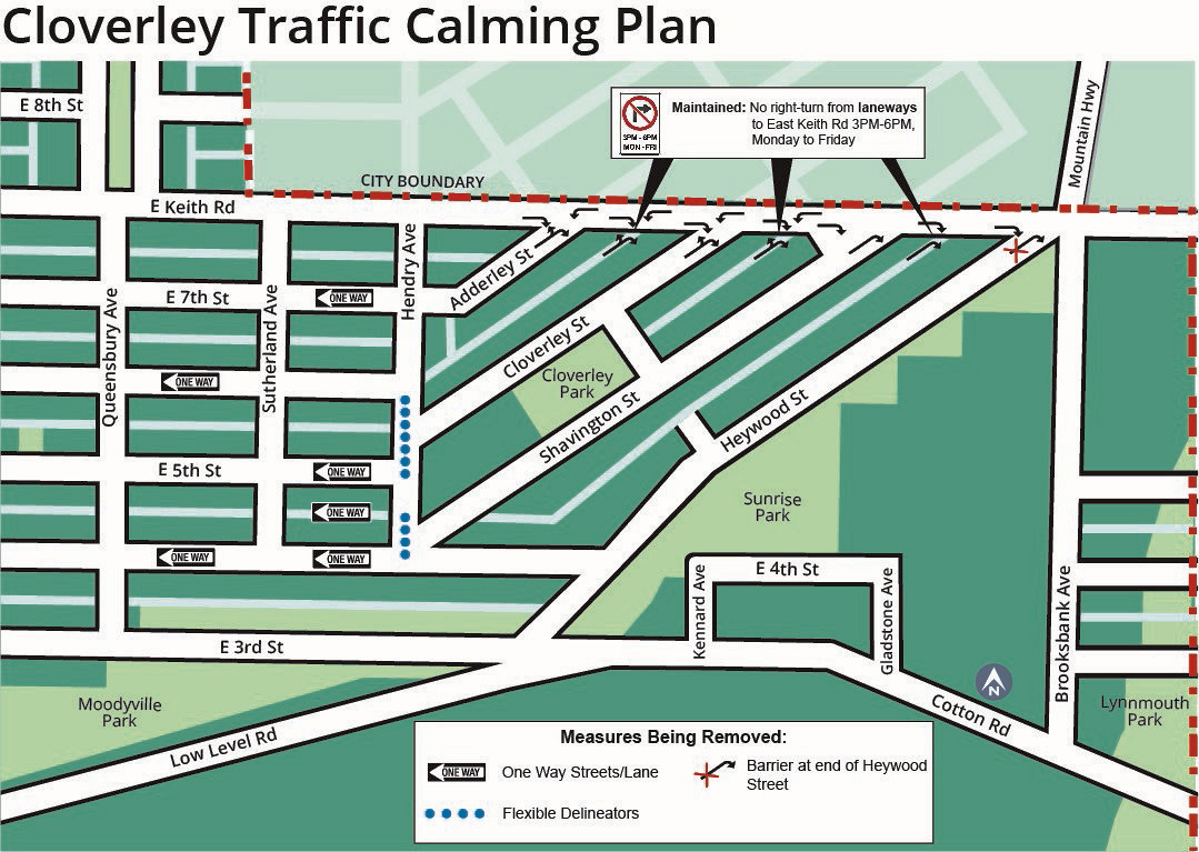
Why Did We Remove the Traffic Calming Measures?
Additional information on why this decision was made is available in our Information Report to Council (April 2021).
- The measures in place haven't helped to reduce overall traffic volumes in the neighbourhood during incident days, and are contributing to higher volumes of vehicles in lanes and on certain blocks.
- Some drivers aren't complying with measures and are creating additional safety issues such as traveling in the wrong direction on one-way streets, driving around barriers and delineators, and making illegal turns.
- Resident satisfaction with the pilot measures is low, and support for actions taken to date continues to be mixed.
- The City also explored alternative ways to minimize traffic volume impacts in the neighbourhood. Details may be found here.
2019-2020 Actions & Results
In early 2019, City staff held several meetings with neighbourhood residents. Following these meetings, a survey was mailed to 444 addresses (and was also available online) to learn about community level support, satisfaction with current measures, tolerance for further restrictions, and consideration for ongoing interchange projects. The City received 178 survey responses.
In the spring of 2019, Council directed City staff to hire a consultant to review traffic calming measures which had been undertaken in the Cloverley neighbourhood. The consultant's final review recommended restricting access to the Cloverley area from Keith Road as the only option to completely address this problem. City staff held a community meeting, heard feedback that the proposed measures were too restrictive, and modified the project to balance the benefits and the impacts to the neighbourhood.
In December of 2019 the following traffic calming actions were undertaken in the neighbourhood:
-
Installing centreline delineators on Hendry Avenue between East 6th Street and East 4th Street
- Making the laneway north of 4th Street one-way
- Maintaining existing right turn restrictions between 3-6pm Mon-Fri from laneways onto Keith Road
- Physically restricting right turns onto Keith Road from Heywood Street
In November of 2020, a Cloverley Neighbourhood Traffic Safety Improvements page was launched on the City's Let's Talk platform to learn more about residents' experiences with the traffic calming measures. In addition to a survey, participants were asked to share their ideas and feedback, as well as include their experiences on a neighbourhood map. The Let's Talk page was open until December of 2020, after which City staff analyzed the feedback received.
2017 Monitoring & Results
Implementation of Phase 1 of the Cloverley Traffic Calming Plan took place between mid-June and the beginning of July, 2017.
Following implementation of Phase 1, staff completed a monitoring program that included feedback received from residents, field observations and data collection. The objective was to evaluate the impact of the measures. Findings are summarized below.
Feedback and reports from Residents
Residents communicated with the City to provide observations and feedback as follows:
- Reports of increased traffic volumes on 5th, 6th and 7th Streets.
- Speed humps are not effective in reducing speeds.
- Signage is not respected by drivers, particularly when there are incidents on the Second Narrows Bridge. The more frequent report was about northbound drivers on Queensbury turning right onto 5th Street eastbound.
- Lack of enforcement.
- Increased traffic volumes on lanes.
- Travel distance and time increased for some of the residents on blocks where measures were implemented.
- Some residents reported that safety on the blocks had decreased for them, their children and pets as traffic volumes and speeds increased.
- Some residents were satisfied with the impact that the measures had on their blocks and asked for further refinements. This included some residents from 4th Street.
- Concerns that regulatory signage applied to short-cutters and residents alike.
- Concerns that the data collected was not sufficient to reflect the conditions in the neighbourhood.
Data Collection Key Findings
The data showed that traffic volumes on 4th Street eastbound decreased. Conversely, eastbound traffic volumes on 5th, 6th and 7th Streets east of Queensbury increased during the pm peak hour. Volumes also increased on the 600 block of both 5th and 6th Streets (west of Queensbury). Overall, speeds decreased where speed humps were implemented. Measured speeds were below the posted speed limit of 50 kilometres per hour (kph).
Data Collection Statistics
- Data collection took place over a two-month period from the middle of September to the middle of November 2017.
- A total of 55 counting stations were deployed between Keith Road and 3rd Street and between Ridgeway and Heywood.
- Turning movement counts were collected at five (5) key locations:
- Queensbury at 4th/5th/6th Streets
- Sutherland at 4th/6th Streets
- Field Observations were completed by staff throughout the study period.
- Queue data was recorded from Google Maps Traffic layer at 2:30pm, 3:30pm and 4:30pm during 38 days.
Additional information
- The RCMP deployed resources at the outset of the initiative and thereafter to educate the drivers who frequently use the neighbourhood as a shortcut. RCMP attended several times, as resources permitted.
- Traffic violations were more notable on 4th and 5th Streets. Violations increased when there were incidents on the Second Narrows Bridge.
- Some residents living in the neighbourhood received tickets when turning right onto 5th Street during the restricted hours.
- Incidents on the Second Narrows Bridge resulted in westward queues on 3rd Street and Keith Road.
- It was noted that the highest impact to the neighbourhood was related to the westward queues on 3rd Street.
Monitoring Program Results
From the observations and data analysis, it was concluded that:
- Eastbound traffic volumes decreased on 4th Street, and increased on 5th, 6th and 7th Streets.
- Increases in traffic volumes within the Cloverley neighbourhood are closely related to incidents on the Second Narrows Bridge and westward queues on 3rd Street.
- Typically, when eastbound queues on 3rd Street pass Queensbury, eastbound drivers on 3rd Street detour through the neighbourhood to find a way to Keith Road.
- Drivers, particularly short-cutters, ignore signage when frustrated by long queues and congestion.
- Speed humps effectively reduced vehicle speeds.
- Implementation of physically restrictive measures is the most effective way to discourage non-residents from using neighbourhood streets and encourage them to stay on the arterial roads.
- Restrictive measures impact the travel time and the trip length of the Cloverley neighbourhood residents.
- Enforcement educates drivers, but is resource intensive and not practical to deploy on a permanent basis.
2016 Public Consultations
To better understand local residents’ concerns regarding the short-cutting and speeding issues, in May 2016 the City invited residents to complete a questionnaire. As part of this study, the City also collected traffic information.
Open House #1 - July 5, 2016
The City held a workshop to share the feedback received thus far, the observed traffic volumes and speeds in the neighbourhood. Possible mitigation measures, their effectiveness and impacts on local residents and commuters were explored and discussed. Workshop participants worked in small groups to develop their own traffic management plans.
To see the workshop presentation and ideas generated by the participants, visit the links below:
Open House #2 - September 20, 2016
The City hosted an open house to review the ideas from the July workshop and presented a draft traffic management plan (TMP) for the area. This mitigation plan was developed based on City staff’s analysis and the feedback received through the questionnaire and July workshop. The open house materials can be found below.
Feedback Received on Original TMP
A total of 36 families (7% of households) attended the second open house and 143 responses and comments (29% of households) were received for the feedback survey. 38% of survey respondents indicated a strong level of support and 46% indicated significant concerns about the plan.
- Traffic diversion measure on East 4th Street.
- Additional signage at the Queensbury entrances to the neighbourhood to discourage commuters from using the local roads and laneways.
- A four-way stop at East 6th Street and Sutherland to provide some traffic calming on 6th Street.
- Speed humps on the 700 and 800 blocks of East 6th Street and 7th Street, and on Adderley Street.
- A phased roll out of the project and the effectiveness assessed at each phase.
- Turning restrictions at East Keith Road and East 3rd Street but with exemptions for local residents.
- Increased enforcement.
- The other proposed diverters, particularly the diagonal diverters on East 6th Street, semi-diverter at East 4th Street and Heywood Street, and the full diverter in the lane between Shavington Street and Heywood Street, would create too much inconvenience for residents.
- The proposed diverters may funnel traffic into the laneways and onto East 5th Street.
- The situation will improve with the completion of the Keith Road bridge, so the plan should be put on hold until the bridge is complete.
- Semi-diverters on two-way streets would require residents on one side to make U-turns to park.
Revised Traffic Management Plan Implementation
Based on the feedback received, the City developed a revised TMP that involved a phased implementation of measures. This revised TMP was presented at three pop-up information sessions in the Cloverley neighbourhood in late February, 2017. Staff from the City and RCMP were at the sessions to explain the revised plan and answer questions.