Helping students walk and roll independently and safely to the new Cloverley Elementary School.
As part of the Safe & Active School Travel Program, the City of North Vancouver and North Vancouver School District (NVSD) are upgrading transportation infrastructure to help students walk and roll independently and safely to the new Cloverley Elementary School ahead of the school’s opening day in September 2026. This long-standing partnership delivers infrastructure, policy and programs to schools across the City.
Planned Improvements
School Zone
Whether a child walks, rolls, takes transit or is dropped off near the school, every journey involves walking on a sidewalk and often times, crossing a street. This is why the infrastructure around a school zone prioritizes slower vehicle speeds and measures to improve the visibility of our smallest residents:
- 30 km/h school speed zone with speed humps;
- Raised crossings with curb extensions to make children visible to drivers, shorten crossing distances and slow vehicles;
- More streetlights, with pedestrian level lighting to improve visibility;
- Wider sidewalks on Shavington, Hendry, Kennard and portions of Cloverley, where grade permits, to improve accessibility and comfort;
- New pick-up and drop-off signage to align with accessible paths, stairs and entrances to the school and daycare.
Review the map of planned improvements within the Cloverley school zone.
Catchment Area
Reducing barriers and improving comfort to walking or rolling to school are important investments for safety, health and reducing congestion near schools and across our City.
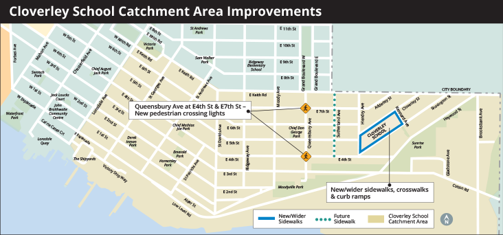
Improvements are planned within the school’s catchment area which extends west to Lonsdale and is bounded to the north by Keith, to the east by Lynn Creek and to the south by the waterfront.
Along Queensbury Ave at E 4th St and E 7th St, new crosswalk markings, curb extensions, Rectangular Rapid Flashing Beacons (RRFBs), and improved lighting will make these arterial crossings safer.

(Example of planned improvements to Queensbury Ave, Chesterfield and W 21st St)
Sutherland Avenue, between E 4th Street and E Keith Rd, is one of the last remaining areas with no sidewalks on either side of the street. Work is ongoing to construct a sidewalk on one side of Sutherland Ave in the near-future. More information will be shared as the design is developed.
View larger image.
Following the school opening, the City will continue to work with NVSD, the school’s PAC, parents, and the surrounding community to understand emerging travel patterns to make further improvements.
How Improvement Decisions Were Made
The delivery of safe and comfortable transportation infrastructure is informed by policy direction, traffic engineering, safety standards and local context.
Improvements around Cloverley Elementary are aligned with the City’s Mobility Strategy, which guides the long-term vision for safer, more inclusive, and accessible streets. This policy direction helped define these specific mobility goals for Cloverley Elementary:
- Slower driving speeds and more visible pedestrians to create safer conditions for all;
- Continuous and comfortable sidewalks to make walking a more practical option for more families;
- Aligning intersection and crossing improvements with desire lines to school entrances to help avoid unsafe behaviour; and
- Making high-traffic roads less of a barrier by providing safe and protected crossings.
The design was then developed considering how to achieve these within the local and surrounding community context. In the Cloverley area, this includes:
- Neighbourhood transportation context: the existing travel patterns, parking demand, points of entry and exit, and the impacts of bridge incidents on the local streets;
- The location of the school and where students are likely to be approaching from based on registration;
- Site specific considerations like the position of the school, the steep site topography and the influence of entranceways on desire lines and pick-up/drop-off activity; and
- Observed behaviours of children and parents during drop-off and pick-up.